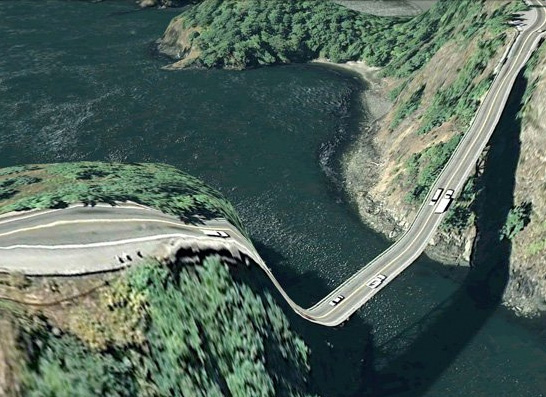
"Artist and programmer Clement Valla...has collected dozens of images of warped bridges spotted from California to the Catskills.
"Valla's unusual collection puts an alien twist on familiar sights. 'I travel through Google Earth looking for strange mappings of the two dimensional onto the three dimensional that provide fabulous and unintentional distortions. These images are like funhouse mirrors—strange illusions and reflections of the real,' Valla said."
The original article and more pictures are at huffingtonpost.com.
Mike
(Thanks to Stan Banos)
Send this post to a friend
Please help support TOP by patronizing our sponsors B&H Photo and Amazon
Note: Links in this post may be to our affiliates; sales through affiliate links may benefit this site. More...
Original contents copyright 2011 by Michael C. Johnston and/or the bylined author. All Rights Reserved.
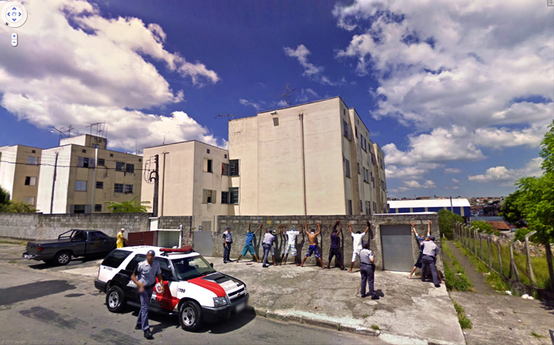
Featured Comment by Sam G.: "Another example of...um...Google Art? Jon Rafman collects images from Google's Street View. It may be more conventional looking than melting bridges but it can be just as surreal."
An explanation of the "melted bridges" effect from GKFroehlich: "The satellite photos Google uses have a particular resolution; that is, there is photo information (color, brightness) at specific grids in X and Y (or Lat and Long). The underlying terrain-elevation model they're using (there are many sources) has much coarser resolution. They project the image info onto the underlying elevation info, but the bridges in these examples fall between the terrain-elevation samples.
Think of it like a large, flexible, photographic print being draped over a terrain model that's a grid of little posts, each representing the elevation at that point. On your print, the image of a canyon falls into the canyon, just as it should, because the posts in the canyon are shorter than the posts representing the higher ground on either side. But unless there are terrain-elevation posts right at the position of the bridge for the image of it to 'land' on, the image of the bridge in your print will also sag into the canyon of shorter posts, and thus will appear as at the link above."
Mike says: Thanks Gary!


Good things those guys got there before that wall fell down. ch
Posted by: CharlieH | Wednesday, 16 March 2011 at 03:04 PM
I don't get it.
I mean, I get that they are surreal, fascinating and of interest, I just can't quite understand why these images turn out the way they do. Is it because the GPS maps the terrain only and not the bridge?
Anyone?
Posted by: charlie | Wednesday, 16 March 2011 at 05:47 PM
There's another thing I don't get, mostly about the Google Street View pictures, since the melted bridges could be considered "art".
#1-Google takes a lot of dull pictures (cool pictures of course, because you can "travel" throuh the streets).
#2-Someone goes into their web site, takes a few screen captures and uploads them to his own website. Plus, he takes credit for them.
I don't get it, How's that related to real photography at all??
I'm sorry, maybe it's just me, but I don't get it....
Posted by: Gaspar H. | Thursday, 17 March 2011 at 07:49 AM
It has nothing to do with taking credit. He's not saying it's his work. It's just some interesting anomalies from Google Earth, that's all.
Mike
Posted by: Mike Johnston | Thursday, 17 March 2011 at 07:54 AM
I too would love to know how they're created. I sure accept that they are photography, subspecies digital, but I'd love to know what their subsubspecies is. Artifacts created by connecting different views by some unintentionally creative algorithm? Jokes from out of the bowels of Google? Momentary spacetime warps visible only from space?
Posted by: Michael | Thursday, 17 March 2011 at 01:05 PM
@Charlie:
The satellite photos Google uses have a particular resolution; that is, there is photo information (color, brightness) at specific grids in X and Y (or Lat and Long). The underlying terrain-elevation model they're using (there are many sources) has much coarser resolution. They project the image info onto the underlying elevation info, but the bridges in these examples fall between the terrain-elevation samples.
Think of it like a large, flexible, photographic print being draped over a terrain model that's a grid of little posts, each representing the elevation at that point. Your print falls into a canyon, because the posts in the canyon are shorter than the posts representing the high ground on either side. Unless there are posts right at the position of the bridge for it to "land" on, the print will sag into the canyon of shorter posts, and the image of the bridge will appear as in Valla's collection of photos.
----------
As for the so-called street-view shots that Rafman collects -- I don't spend all day perusing street view on Google, but in my experience I've NEVER seen street-view photos like the majority of examples on that link. The camera's point of view varies too much, the quality (resolution) of many of them is way too high, and there are other things that just don't ring true. My initial reaction is that they're complete fakes. Maybe Rafman should take credit for them.
Posted by: GKFroehlich | Thursday, 17 March 2011 at 03:39 PM
Yes, thanks for that explanation...I guess I was sorta on to the idea.
Posted by: charlie | Thursday, 17 March 2011 at 06:35 PM
Sam G: Thanks! Those pictures collected by Jon Rafman were fascinating.
Mike: you have always advocated for each city to have a dedicated photographer whose job it was to go around photographing the people and buildings in the city, the daily life, and to record it for posterity. This collection makes it pretty clear that Google may be getting close to achieving that goal for a whole host or cities (though obviously limited to what is visible from the street). An absolutely fascinating portrait of life at the start of the 21st century...
Regards,
Adam
Posted by: amcananey | Friday, 18 March 2011 at 08:17 PM